Mile End
From: "The Copartnership Herald", Vol. III, no. 33 (November 1933)
According to the direction in
which one might be going, the first milestone eastwards
out of London or the last before arriving there, stood
until recent times a little to the west of the Black Boy
Inn. It reminded passers-by, of the turnpike road, the
rattling four-horse coach, the chaise with its
postillion, the steady moving team with lumbering wain,
and all those things which made up the variety of road
transport in the early nineteenth century. Here
travellers 'on the outset of their journey or in coming
near to their destination saw Mile End, and thereabouts
the houses of the well-to-do, which for the greater part
were to the south of the highway towards Stepney Church.
The
mile was measured from Whitechapel. In an earlier - much
earlier - period, however, another had been taken, that
from Aldgate, the gate itself, which terminated where
Cambridge Road now is and where many years afterwards the
toll-house was erected. A writer in the time of Queen
Elizabeth thought that Mile-end Green was so-named
because of it being of that extent, but Mile End
considered as a place-name appears to have come into
existence independently of that fact, and had been given
to a locality beyond the stated distance from the city,
and without it being precisely applied to a defined spot.
When, in the course of time, the adjoining hamlet of
Ratcliff made its boundary and certain parishes were
separated from the mother church, a large area, most of
which consisted of fields, was left over, and recognised
as being in the care and keeping of the hamlet of Mile
End Old Town. It was distinct from the New Town which
arose and became attached to Whitechapel and
Spitalfields. [The] remarkable outline of the hamlet,
that in its greatest length measures a mile and
three-quarters, should not be passed unnoticed as the
little-known fact will be made clear that Mile End Old
Town penetrates close up to Whitechapel Church in the
form of a wedge, representing the old common land known
as Mile End Green
Writing in 1578, the chronicler Holinshed said:
"This common land was sometimes, yea, in the memorie
of men yet living, a large mile long (from Whitechappell
to Stepenheth church) and therefore called Mile-end
green; but now at the present, by greedie (and seemeth to
me, unlawful) enclosures, and the building of houses,
nowwithstanding hir maiesties proclamation to the
contrarie, it remaineth scarse a halfe a mile in
length."
Perhaps once upon a time many an ancient man in his
latter years recalled, like Mr. Justice Shallow, the days
of his youth, when archers held their meetings on the
Green. King Henry the Eighth, who encouraged this noble
exercise, gave his patronage to a company of bowmen who
practised here. Coming one day to see their performance,
he was so pleased with the display of skill that he
instituted the " Famous Order of Knights of Prince
Arthur's Round Table or Society." Every good
marksman who was admitted a member became identified with
the name of one of the legendary knights. In the
spring-time pageants known as Arthur's Show took place in
which appeared competitors from Shoreditch, Shacklewell
and Finsbury. The scene was gay with pavilions and tents
adorned with banners and pennons, and the spectacle
attracted many onlookers from far and near. The
entertainment concluded with a feast for which a buck of
the season had been presented to him who was Prince
Arthur to regale him and his companions after their
exertions of the day. Shakespeare refers to this on the
occasion of Falstaff's visit to old Justice Shallow [1], when the latter prated of the
wildness of his youth when he was a student in the Inns
of Court. "I remember at Mile-end Green, when I lay
at Clement's-Inn, - I was then Sir Dagonet in Arthur's
show...." It was not the recollection of his having
acted the part of a fool in a play but of his pride in
having been one of a merry company, and according to his
own account a mad fellow in those times.
When England was threatened by Spain in 1588, it was
on this Green that the men of the City assembled to
exercise themselves in martial array. Allusions to these
musters were made by Elizabethan writers often in a
jocular manner. The following quotation [2] from a delightful old
play refers to a sham fight:-
MICHAEL: Is not all the world Mile End, mother?
MISTRESS MERRYTHOUGHT: No, Michael, not all the
world, boy; but I can assure thee, Michael, Mile End
is a goodly matter; there has been a pitch-field, my
child, between the naughty Spaniels and the
Englishmen; and the Spaniels ran away, Michael, and
the Englishmen followed: my neighbour Coxstone was
there, boy, and killed them all with a birding piece.
Two hundred years before, in 1381, Mile-end Green had
been the place of riot and tumult, for on it gathered the
men of Kent and Essex who had taken part in what is
called Wat Tyler's rebellion. On the 14th June the
insurgents from the two counties joined forces there. The
young King, Richard II, who was only sixteen years of
age, rode out of the Tower and listened to their tale of
grievances (which were, indeed, bitter wrongs), and
promised all they asked. The promises, however, were
never realised. The following day they assembled in
Smithfield, and the death of Wat Tyler there by the
dagger of Sir William Walworth, and the action of the
King who placed himself at the head of the insurgents,
brought to a sudden and dramatic close the only
spontaneous popular rising on a grand scale presented in
our history. Among those who took part in the final scene
was Sir John Philpot, an eminent citizen of London, a man
who did great service to the realm in its defence against
foreign enemies. He is referred to on account of his
possessing then an estate at Mile-end which was called
"Hull Amilesend," a curious designation in
which the name of the locality is to be observed.
All that is left of the old Common is the small
remnant that survives as Stepney Green. It would be wrong
to suppose that this spot should be identified with the
exact position of the occurrence of events belonging to a
period before the eighteenth century. As an instance, the
house of Henry le Waleys or Le Galeys is described as
being on Stepney Green, which may be taken to mean
anywhere in its modern vicinity. At this house Edward I,
in 1292, held a Council, often improperly referred to as
a Parliament, to deal with the dispute between the
citizens of London and the merchants of Gascony
concerning the importation of wine.
That portion of the hamlet lying near to St. Dunstan's
Church, as it was in the similar case of Ratcliff, was,
and is still, apart from any allusion to the borough
itself [i.e. the Metropolitan Borough of Stepney],
referred to as Stepney. Indeed, here was the old village
whose description and precise situation is not understood
by those unacquainted with the boundaries of the two
hamlets at this place.
Those who lived in houses in this neighbourhood were
considered as residents of Stepney, although for the
purpose and conduct of local affairs by the vestry, they
may have been of either hamlet. Some of these men were
notable in their day, and should provide sufficient
interest to our readers for an account to be given of
them on a future occasion.
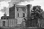 The illustration [left]
is taken from Lyson's Environs of London,
published in 1791, in which it is described as "A
Curious Gate at Stepney," and this "house by
Tradition is called King John's Gate from what authority
is not known, but will serve as a specimen of Variegated
Brick work. It is reputed to be the oldest house in
Stepney." The gateway stood on the modern Stepney
Green, nearly opposite the Rectory, on the site of King
John Street, and formed part of a large mansion belonging
to the first Marquis of Worcester who in 1597 resided
there. In 1663 it was occupied by the Rev. Matthew Mead,
an eminent dissenting divine. Here his son Richard, the
celebrated physician, was born; and here, as it is
recorded in his life, he first commenced the practice of
his profession.
The illustration [left]
is taken from Lyson's Environs of London,
published in 1791, in which it is described as "A
Curious Gate at Stepney," and this "house by
Tradition is called King John's Gate from what authority
is not known, but will serve as a specimen of Variegated
Brick work. It is reputed to be the oldest house in
Stepney." The gateway stood on the modern Stepney
Green, nearly opposite the Rectory, on the site of King
John Street, and formed part of a large mansion belonging
to the first Marquis of Worcester who in 1597 resided
there. In 1663 it was occupied by the Rev. Matthew Mead,
an eminent dissenting divine. Here his son Richard, the
celebrated physician, was born; and here, as it is
recorded in his life, he first commenced the practice of
his profession.
It was not until the nineteenth century had well
advanced that the neighbourhood was developed for
building upon, at first but very slowly. From the earlier
of the two maps, that showing the hamlet two hundred
years ago, some idea can be obtained why so large an
extent of territory should have become a unit for local
administration. It was in consequence of the population
being confined to a very small part of the entire area.
It will be observed that at that time the name of the Old
Town was given to that part of the main road into Essex
immediately east of Dog Row, now known as Cambridge Road.
Here was a favourite place for the erection of almshouses
known as hospitals for poor and decayed folk. There were
those of the Skinners and the Vintners Companies, Trinity
House, and Judge Fuller. Along the north side of the road
were large houses as far as where the People's Palace now
stands, after which the thoroughfare became the road to
Bow. The Globe Road of to-day then bore the ominous name
of Theeving Lane, and Coborn Road is designated Bare
Binder Lane.
by Sydney Maddocks
[1] Quotation is from The Second Part of King
Henry IV, Act III, sc. 2.
[2] Beaumont
and Fletcher: The Knight of the Burning Pestle, Act II,
sc. 2.
Reprinted with permission of David Rich, Tower Hamlets History On Line.