| Author |
Message |
    
Chris Scott
Chief Inspector
Username: Chris
Post Number: 787
Registered: 4-2003
| | Posted on Wednesday, December 24, 2003 - 1:08 pm: |       |
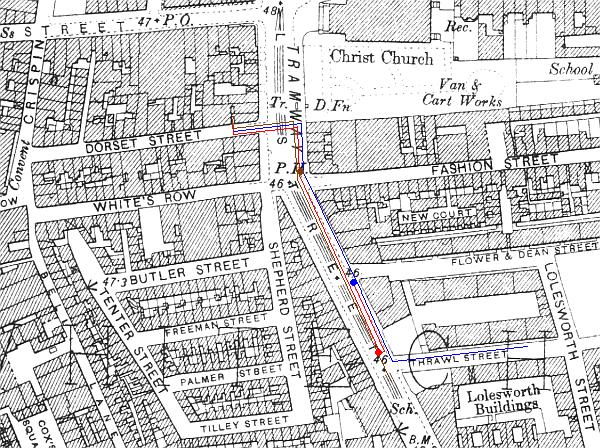
I recently acquired a large scale map of Whitechapel and area from 1894 and have started an exercise I have been meaning to do for my own use for some time.
Reading witness accounts of their movements it can be difficult keeping all their relative positions clearly in mind.
What I intend doing is to represent these graphically on a large scale map.
As a test one I have done the map below to show the movements outlined in George Hutchinson's statement.
the key is as follows:
Blue line - Hutchinson's reported movements
Red line - Kelly's reported movements
Brown line- reported movements of the man seen by Hutchsinson
Blue circle - place where Hutchinson met Kelly
Red circle - approximate place where kelly met the man
Brown circle - place where Hutchinson stared into man's face.
Hope it's of interest - will post any more as I do them
Chris
 |
    
Donald Souden
Detective Sergeant
Username: Supe
Post Number: 84
Registered: 10-2003
| | Posted on Wednesday, December 24, 2003 - 1:31 pm: |       |
Chris
Fantastic! I can only hope you will be able to find the time to continue with other victims and witnesses.
Don. |
    
Frank van Oploo
Detective Sergeant
Username: Franko
Post Number: 86
Registered: 9-2003
| | Posted on Wednesday, December 24, 2003 - 6:23 pm: |       |
Hi Chris,
This is great! I like maps, because they tell a lot - certainly when people's dynamics are added to them - in only one glance.
I see one triviality, though - that is, if I'm right. English is not my native language, so I hope you'll forgive me if I'm wrong, but doesn't 'I was coming by Thrawl Street' mean that Hutchinson 'was passing by Thrawl Street' coming from the intersection between Wentworth St. and Commercial St. rather than 'coming from Thrawl St.? I feel it's important in the sense that he passed by the Victoria Home if I'm correct and this was of course the place where he normally slept.
Merry Christmas!
Frank |
    
Chris Scott
Chief Inspector
Username: Chris
Post Number: 789
Registered: 4-2003
| | Posted on Thursday, December 25, 2003 - 10:37 am: |       |
Interesting point Frank - I took the phrase to mean I was passing by way of Thrawl Street but your reading makes more sense.
Back to the grpahics package!!! :-)
Happy Christmas
Chris |
    
Chris Scott
Chief Inspector
Username: Chris
Post Number: 791
Registered: 4-2003
| | Posted on Thursday, December 25, 2003 - 10:50 am: |       |
Re the above, does anyone know the exact location of the Victoria Home on Commercial Street please?
Chris |
    
Natalie Severn
Detective Sergeant
Username: Severn
Post Number: 124
Registered: 11-2003
| | Posted on Thursday, December 25, 2003 - 12:09 pm: |       |
Chris-Brilliant idea-and thanks-and Happy Christmas!
The Victoria Home was situated at 39-41 Commercial Street ie on the corner ofWentworth Sreet and Commercial Sreet and opposite the Princess Alice Public House[now the City Darts].
Cheers and enjoy the rest of Christmas!.
Natalie. |
    
Glenn L Andersson
Chief Inspector
Username: Glenna
Post Number: 851
Registered: 8-2003
| | Posted on Thursday, December 25, 2003 - 9:04 pm: |       |
Chris,
Once again you have done a brilliant contribution to the investigation. A very interesting effort.
All the best holiday wishes.
Glenn L Andersson
Crime historian, Sweden |
    
Chris Scott
Chief Inspector
Username: Chris
Post Number: 792
Registered: 4-2003
| | Posted on Friday, December 26, 2003 - 10:20 am: |       |
Hi all
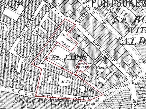
as another example of graphic showing of evidence given, the map below shows PC Watkins' beat round and near Mitre square on the night of the Eddowes' murder. The way he described his beat at the inquest, he would have patrolled his beat anti clockwise. this gives a clearer idea of how close he was to the square at all times.
Hopes it's of interest
Chris
 |
    
Chris Scott
Chief Inspector
Username: Chris
Post Number: 793
Registered: 4-2003
| | Posted on Friday, December 26, 2003 - 10:35 am: |       |
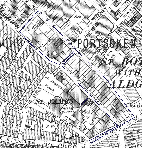
This map shows the beat of PC Harvey on the night of the murder of Eddowes. Again he would have patrolled this anti clockwise
Chris
 |
    
Natalie Severn
Detective Sergeant
Username: Severn
Post Number: 127
Registered: 11-2003
| | Posted on Friday, December 26, 2003 - 1:50 pm: |       |
Chris.Thanks again these routes are really valuable.[did you miss my post giving exavt address of Victoria Home?
Best Natalie. |
    
Chris Scott
Chief Inspector
Username: Chris
Post Number: 795
Registered: 4-2003
| | Posted on Friday, December 26, 2003 - 4:49 pm: |       |
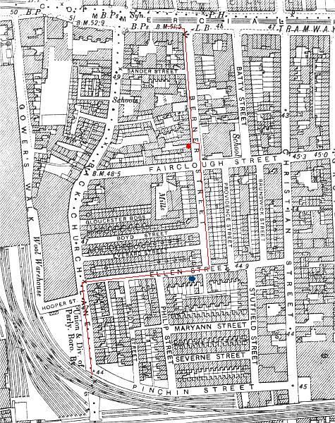
Here is a map showing the most likely route taken by Israel Schwartz on the night of the Stride murder. The red line shows his route and the red circle the scene of the attack in the doorway of Dutfield's yard. From the covering enumerator's sheets of the 1891 census I have been able to establish two things:
1) The even numbers of Ellen Street (Schwartz lived at No 22) were on the south side of the street
2) the house numbering started on the south side at the corn of Ellen Street and Splidt's Street
With this information i have been able to establish where Schwartz's residence was and it is marked with a blue circle.
From the south end of Berner Street I have taken what is the shortest and most logical route to the railway arch but it is possible if he was still trying to evade pursuit (it is not clear from his statement for how much of the distance to the railway arch the second man followed him) he could well have turned down Stuttfield Street into Pinchin Street and run to the railway arch from there. But either way he would have very close to his own residence.
Chris
 |
    
Chris Scott
Chief Inspector
Username: Chris
Post Number: 796
Registered: 4-2003
| | Posted on Friday, December 26, 2003 - 6:57 pm: |       |
Hi Natalie
Just seen your message - thanks for the location of the Victoria Home
Chris
|
    
Chris Scott
Chief Inspector
Username: Chris
Post Number: 797
Registered: 4-2003
| | Posted on Saturday, December 27, 2003 - 12:36 pm: |       |
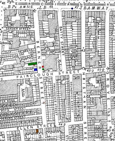
Here is a map showing the various sightings and other features relating to the Stride murder:
Map of Stride's Murder
KEY:
Green building - The Socialist Club at 40 Berner Street
Red Line - the position of Strides's body in Dutfield's Yard
Blue Building - Packer's shop at 44 Berner Street
Red Cross - alleged sighting of Stride at 11.45 by William Marshall
Red Circle - alleged sighting of couple by Matthew Packer 11.00 - 11.30
Brown building - residence of Israel Schwartz
Blue Circle - location of PC Lamb when told of the murder
Green Circle - approximate location of couple seen by PC Smith 12.30 - 12.35
Grey Circle - approximate location of couple seen by James Brown at 12.45
 |
    
Natalie Severn
Detective Sergeant
Username: Severn
Post Number: 128
Registered: 11-2003
| | Posted on Saturday, December 27, 2003 - 1:02 pm: |       |
Chris-such helpful stuff-thanks so much for these.
However I"m unable to see any red cross or blue circle or grey circle.It could be the computeas it still hasnt been for repair-but could you check
its clear at your end? Thanks Natalie |
    
Chris Scott
Chief Inspector
Username: Chris
Post Number: 798
Registered: 4-2003
| | Posted on Saturday, December 27, 2003 - 1:47 pm: |       |
Hi natalie
Glad they're of use
The symbols you mention are showing up here.
The red cross is in the lower half of Berner Street just above the corner with Boyd Street. It is just by the second letter T of Berner Street on the map.
The blue circle is at the top of the map on Commercial Road between Batty Street and Christian Street - just to the left of where it says "47 tramway"
The grey circle is outside the Board School in Fairclough Street just round the corn from berner Street - just above the G of Fairclough Street
Hope this helps
Chris
|
    
Natalie Severn
Detective Sergeant
Username: Severn
Post Number: 132
Registered: 11-2003
| | Posted on Saturday, December 27, 2003 - 2:12 pm: |       |
Chris thats really splendid and again thanks so much for your work on these.I"m about to do a careful study of them.Natalie |
    
Mark Andrew Pardoe
Inspector
Username: Picapica
Post Number: 168
Registered: 2-2003
| | Posted on Saturday, December 27, 2003 - 6:52 pm: |       |
Whatho Chris,
This is good and helpful stuff which allows me get the facts in proportion with the topography. The think about Berner Street; Israel Schwartz tells us he saw our old friend the Pipeman in a door of a pub opposite that den of Socialism. The plan shows there to be a school there and my 1953 Kelleys (sadly I do not have an earlier one) does not list pubs anywhere along Berner Street.
Have I got this wrong or do you know where the pub, and therefore the Pipeman, was?
Cheers, Mark |
    
Donald Souden
Detective Sergeant
Username: Supe
Post Number: 88
Registered: 10-2003
| | Posted on Saturday, December 27, 2003 - 10:51 pm: |       |
Mark,
In his police interview Schwartz evidently said he just saw a man lighting his pipe. In the October 1 interview in the Star the "second man came out of the doorway of a public house a few doors off. . . ." That account also had the second man carrying a knife and shouting a warning to the first man with Stride. Was this simply a fuller account or one deliberately sensationalized by the reporter?
Don. |
    
Chris Scott
Chief Inspector
Username: Chris
Post Number: 799
Registered: 4-2003
| | Posted on Sunday, December 28, 2003 - 10:14 am: |       |
Hi Mark
For Schwartz's account I have gone by the evidence as noted by Swanson and Abberline. Neither of these mention either a pub doorway or a knife, only a 2nd man on the pavement opposite the alleged attack who was lighting a pipe.
Certainly this 1894 map does seem to mark most pubs - if you look at the first one I posted in this thread you will see PH on the map where Hutchison says he bent down to look in the man's face. And just to the north (off the section I have posted) it says PH at the site of the Ten Bells - conversely the Britannia on the corner if Dorset Street is not marked so this is not conclusive. The school on the corner of Berner Street and Fairclough Street is specifically mentioned in the inquest evidence so must have been there in 1888
Hope this helps
Chris |
    
Chris Scott
Chief Inspector
Username: Chris
Post Number: 805
Registered: 4-2003
| | Posted on Monday, December 29, 2003 - 8:36 am: |       |
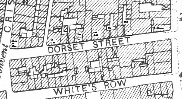
I thought this map of Dorset Street might be of use to some. It shows locations of the three pubs - Britannia, Horn of Plenty and Blue Coat Boy - and various other features. The abbreviations are as follows:
LH = Lodging House
NC = New Court
MC = Millers Court
Chris
 |
    
Richard Brian Nunweek
Chief Inspector
Username: Richardn
Post Number: 507
Registered: 2-2003
| | Posted on Monday, December 29, 2003 - 2:08 pm: |       |
Hi Chris,
Intresting maps, The Dorset Street one Reminded me that there were indeed 3 pubs situated in the street ,which i believe was only 60yards long, one tends to only think of the Britannia. I should imagine all of these three venues were jammed packed every night, I have been in a few jammed packed pubs in my time, and it is very hard , unless on the lookout to notice anybody.
Richard. |
    
Frank van Oploo
Detective Sergeant
Username: Franko
Post Number: 101
Registered: 9-2003
| | Posted on Monday, December 29, 2003 - 2:24 pm: |       |
Hi Chris,
Richard's post made me think of an addition to your fantastic maps to make them even more interesting, namely a scale. What do you think?
All the best,
Frank |
    
Mark Andrew Pardoe
Inspector
Username: Picapica
Post Number: 172
Registered: 2-2003
| | Posted on Monday, December 29, 2003 - 3:44 pm: |       |
Whatho Donald and Chris,
Thanks for taking time to reply. I believe the newspaper report can be ignored on the issue of the knife and so should be similarly treated for other "facts". As the pub is only mentioned in the newspaper report (something I didn't realise) and now think the pub didn't exist. Shame really, I was looking forward to a pint.
Cheers, Mark |
    
Robert Charles Linford
Assistant Commissioner
Username: Robert
Post Number: 1691
Registered: 3-2003
| | Posted on Monday, December 29, 2003 - 6:05 pm: |       |
Chris, when I imagine walking down Miller's Court right to the end, I'm unsure what's supposed to be there. Would the far end have been enclosed by the rear of the building from the next road up? Would there have been rear windows overlooking the Court?
Robert |
    
Richard Brian Nunweek
Chief Inspector
Username: Richardn
Post Number: 514
Registered: 2-2003
| | Posted on Tuesday, December 30, 2003 - 2:35 am: |       |
Hi Robert,
If one were to walk to the bottom of the court,
there appears to be a wall approx 15 ft high, beyond that there appears to be two tenement buidings, but they look quite distant.
Richard. |


